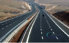
REHABILITATION OF KARASF-SOHREVARD ROAD, ZANJAN, IRAN (KSR-Z)
Factors
Description
Services
Engineering and Design, Construction Supervision
Name
of Project
Rehabilitation of Karasf-Sohrevard Road
Employer /
Client
IMIDRO
Contact
Information of the Employer
Website address: imidro.gov.ir
Email: info@imidro.gov.ir
Phone No: 0098 2141868000
Contract Number
12657, 114660/1402
Type
of Contract
Design and Build (DB)
Contract Duration
Ongoing
Date of Start
Jul 2022
Date of Finish
Ongoing
Duration
of the Project
Ongoing
Key Project Characteristics
·
The axis measures 328+14 kilometers,
undergoing renovation from kilometer 911.22+3 to kilometer 800+6, and
rehabilitation from kilometer 500+6 to kilometer 139.77+11.
·
When designing the cross-sections
for this project, the traffic volume for each axis was taken into
consideration. It was decided to configure the section for renovating the route
as a two-way line, with each line having a width of 3.6 meters. Additionally,
for the rehabilitation section of the route, the decision was made to expand
the width of the existing axis road from the west side.
·
Following the regulations for
out-of-town roads, this route is classified as a collector and distributor
road, with a maximum design speed of 80 kilometers per hour.
·
Traffic estimates were the basis for
determining the appropriate pavement structure for the first 10 years of this
project. It consists of 4 layers with the following specifications: a 15cm
subbase layer, a 15cm base layer, and two layers of asphalt comprising 6cm
binder and 4cm wearing course.
Challenges
and Difficulties
·
Private land ownership
·
The incapacity to
relocate the axis from its current position and the requirement to renovate
the current route owing to social and economic consequences of altering and
varying paths
Description of services
Studies:
·
The initial phase of the
project involves comprehensive studies of traffic flow, road construction,
geology, hydrology, and environmental impact.
·
This also includes the
detailed design of plan, profile, and cross-section maps in various stages.
Additionally, the estimation of traffic flow for the axis over the next 20
years will be carried out with a prediction of the necessary road
construction designs for the axis.
·
Accompanying these
studies is the preparation of assessment maps needed for land acquisition, as
well as the creation of signage and safety maps designed to enhance the
safety of both new and existing routes. Geometric corrections and the design
of route intersections will also be addressed.
Supervision:
·
The supervision phase
will encompass pre-construction oversight, along with technical and support
supervision during the construction period. Furthermore, post-construction
supervision will be provided to ensure project completion and guarantee its
successful operation.
Solution
to Overcome Obstacles
·
Optimizing the approach
and method for improving road infrastructure
·
Modifying the design to
align with future urban expansion plans along the corridor and in the cities
along the route
·
Establishing the
capability for the collective use of mining access roads as an integral
aspect of national highway development
Achievements
·
Enhancement of traffic
flow
·
Mitigation of heavy
vehicle congestion and reduction of pass-through traffic within urban areas
·
Minimization of vehicular
wear and tear
·
Enhanced accessibility
and heightened operational efficiency within regional mining sites
Jul 2022